The Possibility of Acadian Prisoners on Devils Island, Halifax Harbour, in the Period 1755-1768
Terry J. Deveau —
2014-06-24
I've
been trying to track down the source of the information that some Acadian
prisoners were held on Devils Island in
Halifax Harbour for at least part of the period 1755-1768. This factoid came to
my attention a few years ago from a reference to it in Lucie LeBlanc
Consentino's web site (under the heading for Chezzetcook). link
The
source for this information, I found, is Susan Surette-Draper's
pamphlet, Return to Acadie,
2004, p. 20.
Susan
was kind enough to point out to me that her source for this particular bit of
information is the book by Ronald Labelle, Acadian Life in Chezzetcook,
1995, p. 13. link The endnote in this book attributes the source of the
information to Edmé Rameau de Saint-Père, Voyage de Rameau de Saint-Père
en Acadie 1860 : Halifax, as published by La
société historique acadienne (SHA)
— Les cahiers, Vol. 4, No. 8, 1973, p. 345. This is one of a series
of articles printed in the cahiers that were extracted from Rameau's
notes held in the archives of the Centre d'Études Acadiennes (Rameau
1820-1899, 2, 13-2). The relevant portion is as follows:
Chezetcook, c'est le nom de ce village,
a eu pour origine un certain nombre de familles acadiennes, qui ayant été
capturées à diverses reprises dans l'intérieur, après la proscription, furent
dirigées sur Halifax où on les retint longtemps en captivité dans une île qui
se trouve au milieu de la rade méridonale et que l'on
appelle l'île rouge. Ils vécurent là, tantôt des rations de la geôle, tantôt du
produit de leur travail quand on leur permettait de travailler pour les
habitants. Enfin 10 à 12 ans après la grande catastrophe, on leur permit de
s'établir à quelques lieues au nord d'Halifax sur le petit Havre de Chezetcook.
There
are only two things that are surprising or unexpected in this material: the
location of the lengthy Acadian confinement and the name of this island: “l'île
rouge.” It is somewhat well-known from various sources that in the period
1755-1764 there were Acadian prisoners who were kept, at times, on Georges Island, which was close by the South Battery, in the inner Halifax
Harbour (perhaps among other, lesser-known places)—reference the execllent
article on this subject by Ronnie-Gilles LeBlanc: link. It is notable that Rameau's textual
description of his “île” fits Georges Island perfectly, though it definitely does not fit Devils Island. Rameau says that the
Acadians were held in captivity for a long time “in an island that is found in
the middle of the southward roadstead and that is called the red island.”
[The adjective “méridonale” is often used to mean “southern” but it technically means
“southward.” A roadstead is an old nautical term for a navigation
channel.] Devils Island is not in the middle of anything, it is at the
outermost southeastern fringe of the harbour, not in any roadstead at all, but
surrounded by treacherous reefs (witness the wreck of HMS La Tribune,
which initially foundered near there).
On page 312 of the same cahier,
Père Anselme Chiasson writes “Enfin, nous continuons la suite du VOYAGE DE
RAMEAU EN ACADIE EN 1860, en tirant ce qu'il y a de lisible de ses notes
originales en forme de brouillon.” This
made me wonder whether this could be the key to the enigma: if Rameau's
original notes were in the form of a barely-legible rough-copy, he could have
written “l'île ronde,” which is what the
French then called Georges Island (although in earlier times it was
“L'île-aux-Raquetes”), and if hard to decipher it could have been mistaken for
“l'île
rouge” when the article for the cahier
was being edited.
I’m
very grateful to Stephen A. White for taking the trouble to check this for me
in the original Rameau manuscript. He reports that “l'île rouge” is written quite clearly (no capitals) and was
transcribed correctly in the SHA cahier. It seems to me, therefore, that
Rameau himself must have been misinformed, or made a mistake in writing his
notes, because the well-known location, “l'île ronde,” fits his own location description perfectly,
whereas “l'île rouge” does not.
Further
evidence for this error is the fact that although Devils Island has been known
under a number of names throughout history, “l'île rouge” was actually never
one of them. It would have been known to Rameau’s informant as “Île Rouse,”
perhaps, as it had been granted in July 1752 to Capt. John Rous (variously,
Rouse, who’s brother Joseph would later be the first lighthouse keeper on Sambro Island. link). The early French name
for the island was actually “Île Verte” (Green Island), owing to the dense
“forest primeval” that covered it; the British first called it Wood Island for
the same reason. There is a different, very small island (at the southern tip
of McNabs Island) that was called Red Island due to its red-coloured
glacial-till bluffs (today called Thrumcap Island),
but Devils Island is low and rocky, with no till bluffs at all (on Bellin's
1744 Carte de L'Accadie it is
labelled “Île Platte” — link). It was only cleared of its dense
forest cover in the mid-nineteenth century. At the time of the Acadian captivity
in Halifax, then known both as Devils Island and Rouse’s Island, it was owned
by prominent Haligonian Richard Bulkeley,
as son-in-law of the original British grantee (who died in 1760), and a
prominent official in the Colonial government. link
Another
check on the above analysis is to consult Rameau himself. His “notes,” after
all, were for the purpose of his book, published in two volumes in 1889 as Une
Colonie Féodale en Amerique :
L'Acadie. link In the second volume he makes several
references to the “semi-captivity” of the Acadians in Halifax during the period
in question (pp. 174, 178, 183, 184, 197, 200, 201, 214, 220), however, he is
never specific about the location at all. The closest he comes to anything
specific is on p. 178, “… under a regimen of semi-captivity in the suburban
military quarters of Halifax.”
Is
there any source whatsoever, then, that indicates that Acadian prisoners were
ever held on Devils Island?
I
know of none that say so directly. The only candidate, discussed above, appears
to be a mistake resulting from two compounded errors:
(A) a mistake by Rameau or his informant: giving “l'île
rouge” in place of “l'île ronde.”
(B) an interpretation error in assuming that Île Rouse could be also known as “l'île
rouge.”
Given
the above, what do we actually know about where the Acadians were held during
their period of captivity in the environs of Halifax? [What follows are some
notes on this subject that I collected a few years ago, before the
above-mentioned recent article by Ronnie-Gilles LeBlanc appeared. While these
may still be of some interest, the new article gives a much broader treatment: link]. Beamish Murdoch (BM), for one,
frequently refers to the Acadian prisoners (see Murdoch, A History of Nova
Scotia or Acadie, Vol. 2, 1866, pp. 282-285, 312, 373-378, 387, 390, 407,
414-423, 426, 431,437-445, 473)
In
all of these references, Murdoch mentions only twice a specific place where the
prisoners were kept in confinement: Georges
Island. Those two instances are (a) the Acadian deputies incarcerated on
the eve of the Deportation in July 1755 (p. 284), and (b) the 151 Acadians
captured at Cape Sable and kept prisoner in Halifax from June 29 to November 9,
1759, (pp. 373, 375) then taken to England, and subsequently reaching
Cherbourg, France, on January 14, 1760.
Apart
from these two specific instances, however, Murdoch intimates by other remarks
that they most-likely resided in various places and in various degrees of
confinement during their period of captivity in Halifax:
(1)
September 21, 1761, Council resolves that Acadian prisoners are to be employed
in making the road from Halifax to Fort Sackville (p. 407).
(2)
May 9, 1762, Lt. Gov. Jonathan Belcher stated to the Council that he had
information that the French prisoners assembled frequently in great numbers at
the Mass house; ([BM:] where?) also that they were mostly armed, and were
possessed of several armed vessels, under pretence of fishing, particularly
at Dunk cove. He went on with apprehensions of their capturing our vessels
coming into port, taking them to the West Indies, and giving the enemy
intelligence of our situation. The council advised him to seize their vessels,
and to apply to the military commander to disarm and confine the prisoners.
([BM:] I suppose they were Acadian French).
(3)
July 8, 1762, both houses address the Lt. Gov. and ask that those French
neutrals be put under a guard and not permitted the use of boats or shallops,
nor suffered to go abroad without the proper passports (p. 414).
(4)
July 10, 1762, the Lt. Gov. convened a council of war where it was resolved
that the French neutrals, prisoners of war, be collected together, lodged, and
put under such regulations as the commanding officer directs,—those who might
be fishing on the coast were to be brought in; … The French neutrals who
are at work for the inhabitants in Kings and Annapolis counties, to be ordered
to Halifax, under escort of 100 of the militia of Kings county. ([BM:] 130 were
brought to town.) (p. 417).
(5)
July 23, 1762, French prisoners were at work upon the wharf at the Lumberyard,
who were only out of confinement by day upon tickets of leave, and employed as
axe-men by order of major-general Amherst (p. 418).
(6)
July 26, 1762, the House refers to the lenity shewn the Acadian
prisoners—liberty to work at the highways—allowance of provisions, etc. … That
these French neutrals, as they are now collected together, are at present a
heavy charge upon the inhabitants, especially the labouring people, who are
obliged to mount guard every third day and night in their turn, to prevent the
escape of prisoners confined only in open barracks, there being no place of
close confinement to contain such a number (pp. 414-415).
(7)
December 10, 1763, Gov. Montague Wilmot wrote “They are now chiefly victualled
by Government, having no lands or houses. If they are to
remain here they should be scattered in small numbers” (p. 437).
(8)
March 22, 1764, Gov. Wilmot wrote that the chief means of their support was
from the provisions they received ‘on the military list’; they also worked at
high rates, and the wages they got clothed them (p. 440).
(9)
November 9, 1764, Gov. Wilmot writes “Some prisoners, taken in the course of
the war and residing here, have much fomented this spirit [devotion to the
French king and the Roman Catholic religion] … all those people who live in and
about this town have so peremptorily refused to take the oath of allegiance”
(p. 443).
(10)
December 24, 1764, many of the Acadians (prisoners) hired vessels at their own
expense, and 600 of them (including women and children) departed from Halifax
about the end of November for the French West Indies. They had received rations
similar to the soldiers, and they used to supply the town with wood for firing.
On this account their absence was severely felt by the inhabitants (p. 444).
(11)
February 20, 1768, Lt. Gov. Michael Franklin writes that the arrival of the
French Acadians from St. Pierre and Miquelon, [November 13, 1767] disposed to
become British subjects, had made an impression on the French Acadians who were
before in this government, and on a proclamation being issued, they sent in
deputations, desiring permission to take the oaths to the king, and requesting
to have lands granted to them. The council advised 80 acres to be given to each
head of a family, and 40 to each other person … (p.
473).
(12)
There is an additional reference in Murdoch, A History of Nova Scotia or Acadie, Vol. 3, 1867, p. 10 — link: “In May [1782, in the Halifax Gazette], advertised for sale at
auction, ‘all that choice wood lot on the West side of Bedford Bason, near the Block-house cove [today, Fairview Cove, but
then referring to the North Peninsular Blockhouse — link], containing 200 acres, being the next
lot to the Northward of John Tracy, and on which many of the neutral French
live.’ ([BM, 1867:] Behind Birch cove there are the traces of a small village,
said to have been inhabited by Acadians. Mass used to be performed then at or
near Birch cove. There seems to have been a military post kept there.)”
From
the above, it can be seen that there were Acadian prisoners (later, refugees)
in the vicinity of Halifax, subject to various degrees of confinement and
dependence upon victualization, without land of their
own, more-or-less continuously, from 1759 to 1782.
It
is also apparent that only a few of them ever were confined to Georges Island,
and only for relatively short periods. Most of the time they (that is, the men)
were occupied with road building, fisheries, wharf building, and wood cutting,
(in other areas, where dykes existed, they were also employed repairing them)
and would necessarily have been lodged within relatively easy access to the
locations where this work took place—Georges Island is too small for all of
them to have been kept there all the time, and too difficult to access for
taking them from there each day to their work sites.
One
place where the fishery was prosecuted, as named above, was Dunk Cove, now
called Herring Cove, just to the south of Halifax. It is documented that the
Acadian prisoners conducted a fishery out of Herring Cove. Might they have also
been fishing out of other locations? Items (2), (3), and (4) above seem to
imply that there were several such locations in 1762 (italics added to
highlight this purpose). There is also the remark made on June 26, 1764, by
Charles Morris that “about 18 families of Acadians live here [Halifax] who
follow the fishery ... employed by the merchants of Halifax.” link [see fn. 3 in the printed book, the footnotes are no
longer online.] It seems that
this must refer only to the subset of the Acadian prisoner families who were
involved with the fishery; perhaps residing in Herring Cove and possibly other
locations as well.
Although
only 37 acres in extent and deserted today, Devils Island has supported a
thriving fishing community in the 19th and 20th
centuries. In 1920's there were 28 families living there (all fishermen), two
lighthouses, a school, and a post office. By 1932 there were 21 children
attending the school on the island. (John Boileau, Historic
Eastern Passage, 2007, pp. 97-102). link
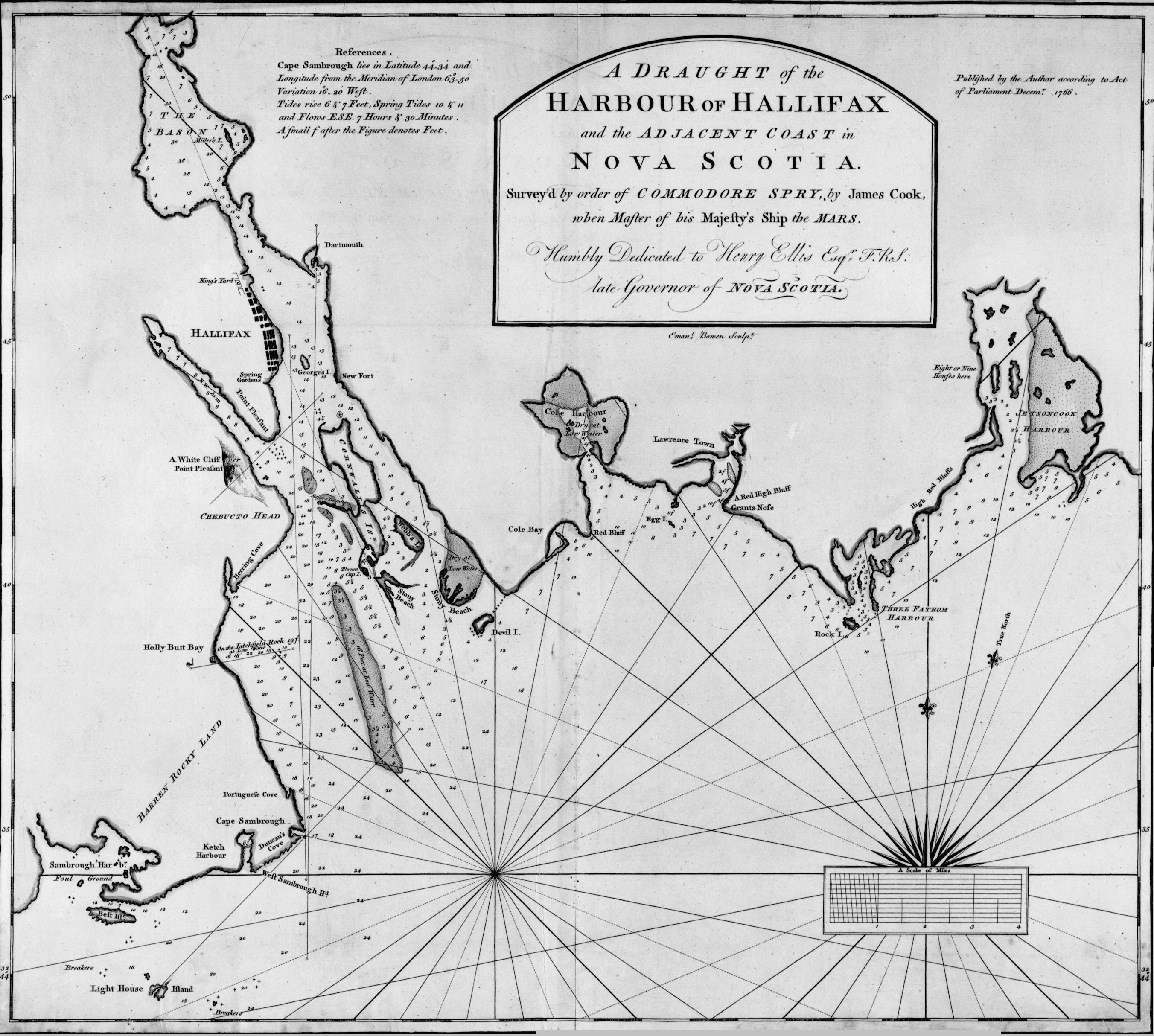
The name Rouse’s Island (variously Rous's Island and Rous Island) dates from 1752 and persists on maps until at least 1814, if not longer. However, the name Devil's (or Devyl’s) Island also dates from an early epoch, appearing on maps at least as early as 1759 (link) and 1766 (link). It is uncertain how the island came by this later name, but according to modern sources (John Boileau, Historic Eastern Passage, 2007, p. 98; Colin Stewart, History of Lawlor Island and Devil's Island in Discover McNabs Island, Friends of McNabs Island Society, 1995, p. 64) “it is now believed that it is a corruption of the name of a former French occupant—Deval, Devol, or even DeVille.” This theory of the origin of the name of Devil’s Island seems to originate with H. W. Hewitt, Dartmouth Patriot, July 6, 1901, who asserted that this is the “real origin of the name.” link
It would appear that, if there is any truth to this theory of
the origin of the name “Devil’s Island”, this supposed French occupant
would have to have been there sometime during or before 1759 (but not too much
before), and long enough to have his name stick. This would have been during
the earliest period of the Acadian prisoner presence in Halifax. As noted earlier,
the land-owner at around this time was Richard Bulkeley,
a prominent Irishman who, though Protestant, perhaps would not have been averse
to French Acadians using his island as a base for the fishery, perhaps
arranging for a market for the catch, and benefiting financially from the
arrangement—in line with the remark by Morris. (This angle is perhaps a
research opportunity).
Another clue comes from the Register of Abbé Bailly, who
travelled around to the numerous groupings of Acadian and Mi'kmaq Catholics
during this period: Registre de l'abbé Charles-François Bailly, 1768 à 1773
(Caraquet), transcribed under the direction de Stephen A. White, Moncton,
1978, 221 pp. The register can be consulted online at this link.
By examination of this document, a list can
be made of the locations and dates near Halifax where Abbé
Bailly recorded meeting with the Acadians:
a. Halifax (July 21, 1768; June 2-4, 1769;
July 6, 1769; Oct. 27 – Dec. 25, 1770; Nov. 29 – Dec. 1, 1771; Apr. 29, 1772)
b. Windsor = Pisiguid = Sainte Famille
(July 12, 1768; Aug. 28 – Sep. 4, 1768; April 30 – May 14, 1769; Jan. 12 &
Mar. 3, 1771)
c. Birch Cove = between Fort Sackville and
Halifax (April 21, 1772; also mentions a birth that took place there prior to a
baptism performed in Eastern Passage on Sep. 28, 1770)
d. Chezzetcook = Chegetkouk (July 23-24,
1768; June 14-25, 1769; Mar. 25-30, 1772)
e. Eastern Shore = Côte-de-l'Est (August
14, 1768; Oct. 14, 1770)
f. Dartmouth (Abbé
Bailly doesn't explicitly go there, but he mentions
several births that took place there in the period 1770 – 1771)
g. Eastern Passage
= Pointe-du-Passage = Pointe-de-l'Est-Passage (Sep.
28 – Oct. 1, 1770)
h. Pointe-du-Diable (July 8-10, 1769)
Birch Cove is of interest with respect to item (1),
the work on the road from Halifax to Fort Sackville. It seems that, 10 years
later, the Acadians who had located there to work on that road in 1761 were
still living in that vicinity, and indeed, based on item (12), even 21 years
later!
Of more immediate concern are Eastern Passage and Pointe-du-Diable. It seems likely that Pointe-de-l'Est-Passage is
where the Eastern Battery (renamed Fort Clarence in 1798) was constructed
in 1754, (repaired in 1762, for which some Acadian prisoners may have supplied
labour) and perhaps where the military victualization was carried-out to the
prisoners residing nearby. Pointe-du-Diable
is more enigmatic. It is a location that I have not found on any map. The only
explanation I have for this toponym is that it may have been the name for the
point of land nearest to Devils Island (where the row of x’s emanates from on
the 1766 map — link). This point is not named on most maps;
sometimes it is called Hartlen Point—but usually that name is assigned
to the next point further along the coast to the southeast. A WWII
fortification was built there, known as Devil’s
Battery, but a few fleeting references (so far not substantiated) call it Devil’s Point Battery.
It is possible that there was an Acadian
prisoner / refugee settlement on the point of land nearest to Devils Island.
(Further research may shed light on this.) It would be close to any
Acadians who may have been fishing out of Devils Island, close to the Eastern
Battery where the rations were distributed (but not too close), and would have
better access to mainland resources (such as day-jobs in Dartmouth for the
women) than would be the case for people actually resident on Devils Island. In
that era, the main community of “Dartmouth” was centred more to the south of
what is the downtown today.
It is pretty clear from the references
citied here that there was a major Acadian refugee presence along the Dartmouth
shore, at least from the Eastern Battery to Hartlen
Point, probably from around 1763 to at least 1772. There is an additional
reference that gives some idea of the magnitude of this presence, and the
approximate date when it may have begun to disperse. In The Story of Dartmouth (1957), J. P. Martin writes, “Many of these
1750 grantees [referring to Dartmouth shore landowners] evidently were
neglecting their Dartmouth holdings, because in 1779 the Government issued a
proclamation threatening prosecution to ‘plunderers, particularly
French-Acadians, who have cut down and carried away timber and grass growing on
granted lands on the east side of the harbor without any leave from the
proprietors’” (p. 93).
From Bailly's
register we can find that one of my ancestors, Jacques Deveau (variously Desvaux, deVaux, Devault, etc.), was one of the family men who met with Abbé
Bailly at Pointe-du-Diable to have his children baptised. When Abbé Bailly was
there in August 1769, Jacques Deveau had not seen a Catholic priest in seven
years, since the time that Abbé Maillard
had baptised one of his older children in 1762. This despite Abbé Bailly's
multiple visits to Windsor, Halifax, the Eastern Shore, and Chezzetcook over
the preceding two years. Where was Jacques Deveau during this time? Was part of
it spent fishing from Devils Island? Jacques Deveau is later identified as a
“fisherman” on a land transaction and is known to have conducted a fishery in
Saint Marys Bay in 1785. Was he the unknown French
occupant mentioned by Hewitt?
Could it have been the name Devault's Island
that ultimately got corrupted to “Devil's Island”? No, Jacques Deveau could not
have been there as early as 1759; at that time he and his family were refugees
from Isle Saint Jean, living and travelling with the Mi’kmaq in the Miramichi-Restigouche area of what is today northern New
Brunswick.
Regarding actual names of candidate
Acadians for the unknown “French occupant,” There are only a few sources that
might suggest possibilities; the best known ones are Bailly's Register (cited earlier) and Manuscripts of Chief Justice Deschamps 1750-1800 (NSARM - Family Papers Deschamps, Isaac - Vol. 32). In the latter, the prisoners
are listed with the number in each Family. link
I don't find any other names in Bailly or Deschamps that make a
good-sounding match, but perhaps there was a “Deval, Devol, or DeVille,” etc. among
the Acadian prisoners fishing out of Devils Island who did not get recorded in Bailly’s register nor in the Deschamps
manuscript of Fort Edward prisoners. The article by Ronnie-Gilles LeBlanc,
cited earlier, also includes an appendix: List
of Acadians Families & Individuals at Halifax between 1759 & 1764. Again, Deveau is the only name in this
list that even remotely sounds like Devil or Diable.
The earliest date that Jacques Deveau could
have gone to Devils Island would be the fall of 1762 (other Acadian prisoners
could theoretically have been sent there as early as 1759). If there was some
now unknown French fisherman based on Devil’s Island at an early date, the fish
traders around the Halifax fish markets may have started referring to “DeVille’s Island” (etc.)—initially not intending to rename
the whole island after him, but just an informal reference to the island where
his fishing was based. The English speaking community probably would have made
the linguistic jump to the name “Devil’s Island” rather quickly (as it has a
natural catchiness, and could have started as a joke or a witticism). With
conditions as despicable as they likely were for the Acadians on the adjoining
mainland, where it seems some were located by 1769 (and likely earlier), it
would be all too poignant and ironic for the French speakers to resist
subsequently picking-up on the linguistic twist of fate and refer to their own
location as “Pointe-du-Diable” (Devil’s Point).
This appears to be the extent of the
available information regarding an association of Devils Island with the
Acadian prisoners of the period 1755-1768. It is likely that Rameau’s
informants told him about Acadian prisoners briefly held captive on Georges
Island (Île Ronde) and possibly
also about a much longer confinement, as fishermen, on Devils Island (Île Rouse). In collecting his notes
together, Rameau may have inadvertently coalesced these two locations into one
and mistakenly written its name as “l'île rouge”.
Later historians, in reading “l'île rouge” in
Rameau’s notes, have interpreted this as a reference to Île
Rouse (Devils Island), which in the end may be partly correct, although also
partly wrong as Rameau himself has apparently confounded it with the Acadian
confinement on Île Ronde
(Georges Island).
deveau
“at”
chebucto.ns.ca
(for my Email
address, combine the three preceding lines into one and change “at” to @)